-

User story: Peter Dimberg models the VA system of the future
Sälen, Sweden, is currently experiencing a high rate of development where many new hotels and holiday homes are being built. This means that everyone must have water & sewer, and then it is important to keep track of whether there is sufficient capacity. Water & Waste in Malung Sälen AB (Vamas) is a municipally owned company in Malung-Sälen municipality that works with just recycling and water and sewerage services. Peter Dimberg is a modeling engineer at Vamas * and one of those who works to ensure that everyone has access to fully functioning water and sewer system.
Text: Sandra Mickelsson
* Since the report was written, Peter Dimberg has had time to move on to a new job and is now at DHI as a project manager for digital services.

Although no two days are the same for Peter Dimberg, his main tasks are to optimize and dimension the pipeline network. Trying to investigate and understand what the water and sewer system of the future should look like is very much about estimating how large the load will be in the future. In some areas, you need to take into account an increased load, while it is not good to oversize either.
– In the mountains, the variation is great during the year, with a very high pressure during the winter and then calm down considerably during the summer. It is therefore necessary to design a system that works under both high and low load and that it is adapted for future conditions, says Peter.
A new map system – which was not just a peephole
When working with the VA network, a map system and functions are needed to, among other things, analyze runoff against the topography. After a few years with Autocad / Civil 3D, Vamas was interested in reviewing the range on the market and what has happened in the development. Although they were generally satisfied with their program at the time, they wanted to see if there was a system with more functions that could help them in their daily work, and which was compatible with other external systems they use.
– Historically, the map system has mainly functioned as a peephole where you can only look at the wires in the ground. We wanted to find a system where you take the step further, from just having a database with information, to something that also simplifies everyday life – today and in the future, Peter explains.

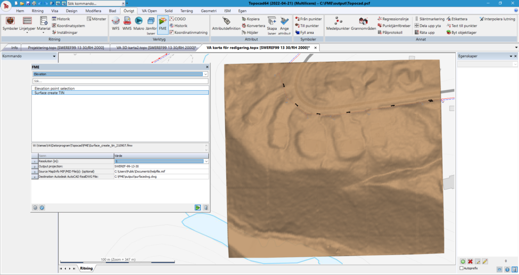
3D surface created in Topocad with FME by specifying the desired area.
Vamas became test pilots for Flex VA
The new map system became a combination of Topocad, database, SM (Cartesia Spatial Map) * and FME (Feature Manipulation Engine) * and where also the completely new function Flex VA was integrated.
– Topocad Flex will be an important piece of the puzzle in our new map system that builds the various components together. Right now, we mainly use it to add and update our management network with associated objects in the database. When everything is finished and the database has been updated, we will, among other things, design and update the VA network via Topocad Flex down to the database, says Peter.
Vamas became one of the first companies to launch Flex VA, which is a function that allows you to connect Topocad to your database. The changes you make take place directly in the database and you can communicate directly with, for example, Topocad or CSM, and integrate models in a flexible and simple way.

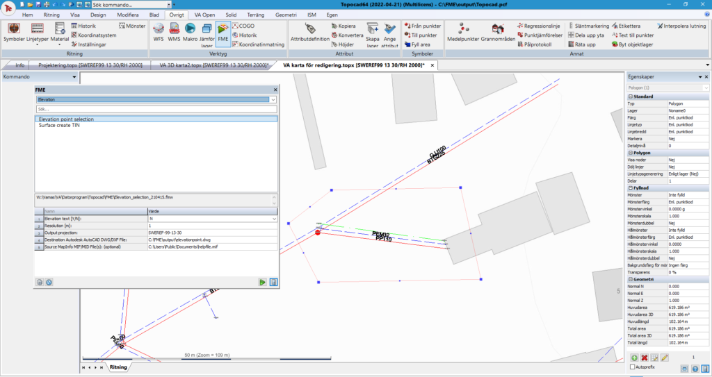
Example of an area for obtaining highlights in Topocad with FME from the survey data’s elevation data.
”Topocad is structured in a self-explanatory way”
The introduction of Vama’s new map system is still ongoing and it is being expanded as in continuous dialogue with the team behind Flex VA. But already now Peter can see how easy it is to use and how much faster it is possible to design in Topocad.
– In Autocad it could take hours to get something good, in Topocad you can get the same result in half an hour. The flow has really been simplified, and Topocad is built in a self-explanatory way. If you want to draw, make changes, ground profiles or breaks, it is easy to find under the menus. It takes a few keystrokes to get what you want, and you do not have to be as familiar with the program as you have to be in Autocad to do the same thing, says Peter.

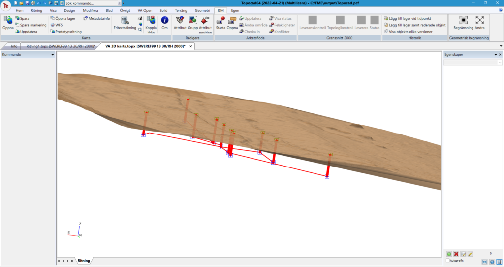
3D view of pipes and wells and how they lie underground. The pipes/wells are retrieved directly from the database and extra extra work is not required more than storing data correctly
Simplified and clearer work process
In addition to the fact that the design goes faster, Peter sees a number of other advantages. Among other things, he mentions that because Flex VA is connected to the database, all designers can access each other’s design work and gain a greater understanding of the whole. Vamas also becomes less dependent on people. If a designer falls ill, others access the same data material and can easily make the modifications required to proceed. In addition, the pricing and agreement with almost unlimited Topocad licenses was quite lucrative.
– The flow from design to storage is also faster before it is visible in the sharp map system. In principle, only the projected objects need to be marked and change status from projected to current to be visible in the map. It also becomes clearer which works have been projected and their status within the municipality. The whole will be more tangible, according to Peter
Peter Dimberg also highlights the integration with the FME as very grateful as it solves any dead ends that may arise in the daily work with models and processing of data
– With integration with the FME, there are in principle no restrictions with what you can do with Topocad for a water and sewer system regarding dimensioning, optimization, renewal, historical analyzes, but above all preparatory work to build a robust VA system that not only works today, but also in the future, Peter concludes.

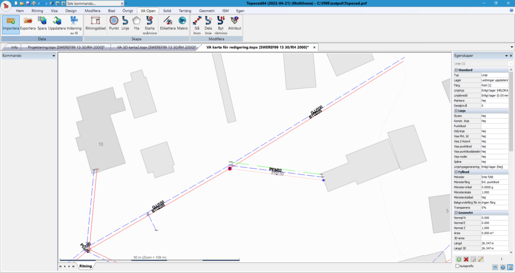
Example of what the water and sewer network can look like in Topocad. All data is retrieved / stored directly from the database via ISM.
This is Flex VA
Topocad Flex is the module that makes it possible to manage the water supply and sewerage network. For example, you can easily create and modify pipes and wells and trackwater flows in the pipes.
The Flex concept is flexible and open in a completely new way. This makes it more user-friendly compared to other similar systems and you can create and edit water and sewer objects with fewer steps. You save directly to the database as much of the functionality is performed there. Thanks to the composite functions, it is easy to divide and join wires, and you can point out and start tracking or draw a surface with just a few keystrokes to see what is inside the surface.
-
More news
-

Topocad 23.2.1 is here!
The latest version of Topocad, 23.2.1, is now available! This update brings enhanced support for various URL formats in WMS services, the new database adapter for ArcGIS Pro now supports circular Arcs, along with numerous other improvements.
Click here to download
Discover all the new features here
Read more -

Adtollo Inside Story: Meet Axel Munktell, Topocad Sales Representative at Adtollo
Name: Axel Munktell Position: Sales Representative, Topocad Employed at Adtollo since: Spring 2023 Background: Recently graduated Bachelor of Science, Industrial and Management Engineering at Örebro University.
Meet Axel, our enthusiastic newcomer to the Adtollo family. Growing up in Alsike, Knivsta, Axel spent four years studying in Örebro before making the move to Stockholm to join...
Read more -

Explore Topocad 23.2: What’s New and Improved!
Discover Topocad 23.2: Packed with new user-friendly features!
Download version
All version news
In this brief video, you can watch Amanda demonstrate the latest news in Topocad 23.2. We have made adjustments to the settings window for point information, introduced a new method for gross error adjustment, and now, when calculating survey data, you have the option to exclude backsight...
Read more -

Topocad 23 is released!
Topocad 23 is the latest version of our popular software for surveying, mapping and design. With new features and improvements, Topocad 23 offers even more possibilities for efficient work and quality results.
At Adtollo, we are proud to continue developing Topocad to meet the needs of our customers. We believe that Topocad 23 will be a valuable tool for surveyors, engineers, architects, and other...
Read more -

Release of Topocad 22.2!
Topocad 22.2 is released!
Watch the video where Jakob demonstrates some of the big news in Topcoad version 22.2, such as digital terrain model (DTM) handeling, import of LandXML, DXF/DGW, and IFC.
Also, a new camera control and input alternatives.
WATCH VIDEO
Read more